

FlyPix AI
AI AutomationUpdated November 10, 2026
No-code GeoAI platform that detects, counts and tracks objects in satellite, aerial and drone imagery using custom models trained from a few labels.
We may earn a commission when you sign up through our links. It does not affect our reviews.
What is FlyPix AI?
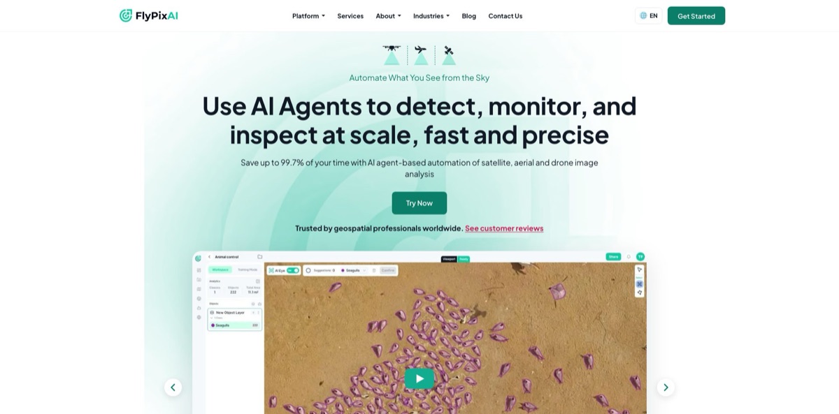
FlyPix AI is a browser-based GeoAI platform from Darmstadt, Germany, that finds, counts and outlines objects in satellite, aerial and drone imagery. You upload a GeoTIFF or connect a WMTS or Cloud-Optimized GeoTIFF source, label a handful of examples, and train an object detection or semantic segmentation model without code. Its ORION assistant finds similar objects from one sample or a short text prompt, and a trained model can then run across whole files, producing vector layers you export to QGIS or ArcGIS. That replaces hours of manual digitizing of buildings, trees, vehicles or debris. The weak spots are cost visibility, since every job burns credits and self-serve prices only appear after sign-up, plus a learning curve that reviewers flag for people new to AI. Pick it if you need repeatable detection over large areas and don’t have a machine learning team.
How to start using FlyPix AI?
Go to app.flypix.ai and click Sign Up. The first screen asks you to “Tell us about you” with your Full name, Organization and Your role, and only then shows the email and password fields or the Continue with Google and Continue with LinkedIn buttons. After registration you choose a subscription plan; when a free plan is offered, Skip for now starts you on it. Onboarding ends on the Projects page, and the Dashboard with your credit balance and storage sits one click away in the left sidebar.
Click New Project, rename it, and open the Files tab (each project also has Models, Datasets and Settings tabs). Drag a GeoTIFF into the upload panel: the limit is 3 GB per file on the Free plan and 50 GB on paid plans. If your imagery already lives online, use + Add, then Import External Imagery, and point FlyPix at a Public COG URL or a WMTS layer instead of re-uploading. No imagery at all? Open Data Market, draw a polygon, set the resolution slider and choose optical or multispectral data; you get an estimated cost range and the FlyPix team confirms price and availability.
The workspace is where the real work happens. Start with ORION: annotate one clear example, and ORION highlights similar objects in the visible area for you to Confirm, or type a prompt such as “Trees” instead. For repeatable detection, switch to Training Mode, draw training regions and label every object of the class inside them, because unlabeled objects are learned as background. Add negative regions without targets, read the Model Training Summary for the estimated credit cost, then pick Object Detection or Semantic Segmentation and click Start Training.
Once the model is ready, click Apply AI Model and choose Full Image or only selected Regions, which keeps credit use down. Review the new inference layer, and if you have two dates, open Changes in the Scenes panel to see Additions, Deletions and Modifications. Export results as GeoJSON, GeoPackage or a zipped shapefile, or use Share to publish a map with link access and, optionally, list it in Community.
Who is it for?
GIS analysts
You spend days tracing buildings, roads, poles or tree crowns by hand before any real analysis can start. FlyPix turns a few labels into a model that digitizes the rest, and the output drops straight into QGIS or ArcGIS as GeoJSON, GeoPackage or shapefile.
Drone service providers and construction teams
Every site flight produces thousands of images that someone has to inspect for progress, materials or risks. A trained model counts and flags the same objects on every new flight, so reports come out in a consistent format instead of depending on who reviewed the imagery that week.
Agronomists and plantation managers
Counting palm trees or checking crop stress across large estates is slow on the ground. FlyPix runs detection on drone or satellite captures and the change tools show what grew, disappeared or moved between dates, which helps you decide where to send scouts first.
Environmental groups and researchers
Mapping beach litter, habitat loss or deforestation usually means tedious manual labeling. Community maps such as the Red Sea Debris project show the pattern: detect, count and measure objects, then share an interactive map with partners or the public.
Insurers and public agencies
After a storm or flood you need affected-building counts fast, and the vendor publishes workflows for building damage assessment, risk management and road maintenance. Before-and-after imagery plus change detection gives you a first damage picture before field crews arrive.
Developers and data teams
You want detection inside your own pipeline, not in another browser tab. The v2 REST API, the official Python SDK and an MCP server let scripts or AI assistants list projects, apply models and read results.
FlyPix AI pricing
FlyPix runs on subscriptions plus credits. Each plan includes a monthly credit allowance and a storage quota, and credits are consumed by model training, AI detections, ORION full-file searches and GeoSense chat answers. Before every heavy job the app shows an estimated credit cost, and the Dashboard lets you Add Credits or Add Storage when you run low. The old public pricing page now redirects to app.flypix.ai, so self-serve prices are shown only after you create an account. Earlier versions of that page quoted plans in euros only. The only USD prices FlyPix publishes today are on its AWS Marketplace listing.
A free plan is available at sign-up for trying the workspace on your own imagery. Uploads are capped at 3 GB per GeoTIFF, compared with 50 GB on paid plans.
price shown in the in-app plan picker after sign-up. No public USD figure was available on the check date, so compare the in-app quote with the AWS contract prices below before you commit.
Described as the plan with essential features, billed as a line item on your AWS invoice, with a free trial offered on the listing.
Adds the assistant labeling features on top of Starter. Eligible purchases can count toward AWS Enterprise Discount Program commitments.
Custom. Private offers through AWS Marketplace or a direct quote from sales; the docs show an Enterprise Unlimited plan, and the AWS listing says API access and quality assurance by GIS experts come with professional plans.
quote-based. You get an estimated cost range per request, and the final price is confirmed after the FlyPix team evaluates it.
FlyPix AI key features
ORION Find Similar
You annotate one sample object, and ORION scans the current view for lookalikes; you can also describe the target with a text prompt such as “Trees”. ORION Search File repeats this across a whole raster and shows the estimated credit cost first.
ORION Smart Segmentation
Smart Point, Smart Brush and Smart Eraser let you mark positive and negative samples while the segmentation updates live, and Island Mode removes stray fragments. It suits areas such as roads, ponds or fields rather than countable objects. You get clean polygons without tracing every edge.
No-code model training
Draw training and negative regions, label the objects, pick Object Detection or Semantic Segmentation and start training. Plans with advanced training add a Target Resolution control with a live preview of the model’s crop window. The AI Models page also lists community and official models you can apply directly.
Change detection and time series
Add scenes from different dates in the Scenes panel, then compare Scene A and Scene B to get Additions, Deletions and Modifications. You can target change sizes from Large to Extra Small, and Workspace Analytics charts object counts per class across scenes. This is the core of monitoring jobs such as construction progress.
GeoSense assistant
A chat panel answers plain-language questions about your annotations: filter, rank, compare and summarize them across vector layers. Since v4.7.0 it can jump the map to a named place and answer about scenes you don’t have open. Answers consume credits, even when you stop one midway.
Flexible data in and out
Upload GeoTIFF, stream Public COG or WMTS layers, or request satellite, aerial and drone imagery through Data Market. Results export as GeoJSON, GeoPackage or zipped shapefiles, with filters and custom property names.
API, Python SDK and MCP
API keys are created in account settings with expiry from 30 days to never, and the official SDK installs with pip install flypix. The MCP server at api.flypix.ai/mcp exposes the same operations to AI assistants. Keys carry your full permissions in that tenant, so store them carefully.
FlyPix AI Pros & Cons
Pros
FlyPix gets a non-programmer from raw imagery to a working detection model with a few labels, which is the main reason to choose it. ORION shortens labeling, and the same workspace covers training, inference, change detection and export, so you are not stitching four tools together. Output formats match what GIS teams already use. The product is actively maintained: the public changelog shows releases every one to two weeks, with v4.7.0 on November 5, 2026 adding shapefile import and export. Developers get a documented REST API, a Python SDK and an MCP server. Start with a community model on your own imagery to see the quality bar before training your own.
Cons
Pricing is hard to judge before you commit. Self-serve prices sit behind sign-up, the AWS contract prices are the only public USD numbers, and actual cost depends on credits consumed by image size and resolution. Reviewers on G2 say the platform can be complex for people without AI experience, and independent reviews are scarce overall. Imagery uploads accept GeoTIFF only, so other formats need converting first, and the Free plan caps files at 3 GB. API keys cannot yet be scoped to fewer permissions than your user account. Run a paid pilot on one representative site before rolling it out across a whole portfolio.
Use FlyPix AI if you want…
- Count trees, vehicles or panels in drone imagery.
- Train custom detection models without writing any code.
- Track site changes between two satellite or aerial captures.
- Replace manual digitizing of buildings and roads.
- Export detected objects straight into QGIS or ArcGIS.
- Order satellite or drone imagery for a drawn area.
- Query your map annotations in plain language with GeoSense.
- Run geospatial detection from Python scripts or AI assistants.
- Buy geospatial AI through your existing AWS account.
FlyPix AI alternatives

FlyPix AI Reviews
A construction firm reviewing it on G2 says FlyPix gives them full visibility over large-scale site inspections, but the team found it hard to learn straight away as beginners.
A large-scale farming user on G2 calls it cost-effective for spotting objects and field problems remotely without expensive equipment, while noting it still needs small improvements across the board.
Another G2 reviewer credits it with accurate detection and classification for remote construction inspections and catching anomalies early, but warns it can be complex for users with no AI background.
The testimonials on the vendor’s own customer page, from customers and partners in Germany, India, Belgium, Italy and the US, praise a quick path from idea to proof of concept; treat them as vendor-selected quotes rather than independent reviews.
FAQ
Is there a free version of FlyPix AI?
Yes. You can start on a free plan after sign-up by choosing Skip for now on the plan screen. It limits GeoTIFF uploads to 3 GB per file, while paid plans accept up to 50 GB.
What imagery can I use with FlyPix AI?
The platform works with satellite, aerial and drone imagery, including multispectral data. You upload GeoTIFF files or connect a Public COG, a WMTS layer or a Rasterless base map, and you can request new imagery through Data Market.
How do FlyPix credits work?
Each plan includes monthly credits that are spent on training, AI detections, ORION full-file searches and GeoSense answers. The app shows an estimated cost before every job, and you can top up from the Dashboard with Add Credits.
Do I need coding skills to use FlyPix AI?
No. Labeling, training, inference, change detection and export all run from the browser workspace. Coding only comes in if you want the REST API, the Python SDK or the MCP server.
Can I export results to my GIS software?
Yes. Vector layers, selected annotations, whole files, datasets or workspaces export as GeoJSON, GeoPackage or zipped shapefiles, which QGIS and ArcGIS open directly.
Does FlyPix AI have an API?
Yes. There is a v2 REST API authenticated with API keys, an official Python SDK on PyPI named flypix, and an MCP server so assistants such as Claude can work with your FlyPix data.
Can I buy FlyPix AI through AWS?
Yes. Since March 2026 the platform is listed on AWS Marketplace with Starter at $200/month and Advanced at $600/month on 1-month contracts, plus private offers for custom terms.
How does FlyPix AI handle my data?
FlyPix AI GmbH is based in Germany and states that it processes customer data under GDPR. Inside a tenant, owners control access through tenant and project roles, and shared maps can be limited to you or opened to anyone with the link.
Similar tools
 GPT WorkspaceAI agent for Google Docs, Sheets, Slides, Gmail and Drive that edits your files, runs GPT formulas in bulk and automates routine
 FPT.AIVietnamese enterprise AI platform from FPT Smart Cloud for chatbots, call-center voicebots, document reading and eKYC that automate customer operations.
 Frigate NVROpen-source NVR that runs real-time AI object detection on your own hardware and sends camera events to Home Assistant and other MQTT